Friday, July 10, 2009

CANYON SAFARI ON MT.IDA


It was a great adventure for us... We met 10 a.m and said goodbye at 8 p.m. Seems to be short but really a deep experience one should have.


One of the unexpected lakes to swim...


I was scared to fall down....


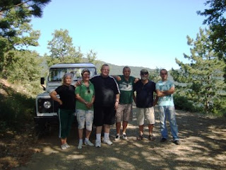
Our small group ready to conquer!


The steps of a bear who has just passed by!


A natural passage...


This cemetery belongs to the soldiers of Sultan Mehmet the Conquerer who had conquered Constantinopolis. His boats were done with the long timbers of the Ida Mountain. So it is of about 700 years. The local villagers visit this place every August and perform their rituals.


Searching what? The deepness of the water!

DARIDERESİ - heaven on Mt.Ida just for you

DARIDERESİ, a heaven 20 km from the city center and
700 metres high from sea level
where you can reach with a car or caravan.


You can play football or swim!


Saturday, April 19, 2008

Natural and Cultural tours

We can offer you the chance to participate in the local cultural and nature tours partnering with the local organizations in our region. Listed below are some of these local attractions

Wooden Birds Etnographical Gallery, Pınarbaşı Creek, Sutuven Waterfalls, Hasan Boğuldu Lake.

Şahinderesi Canyon, Altınoluk Village, Atlar of Zeus, Adatepe Village, Antique City of Pergamum. Entrance is possible with a Professional guide.

Behramkale Village, Antique City of Assos. Assos Harbour, Antique City of Troy.

Entrance to both cities are possible with a professional guide.


Daily boat excursions are available to Assos and Ayvalık.

HOW TO COME?


By Road
Ankara - Altınoluk 460 kms
Izmir - Altınoluk 230 kms
Istanbul - Balıkesir - Altınoluk 380 kms
Istanbul - Çanakkale - Altınoluk 460 kms

By Fast Ferry
Yenikapı- Bandırma 1 hour 45 minutesBandırma - Altınoluk 207 kms

By Airplane
Istanbul Atatürk Airport - Edremit Airport 30 minutes
connection by road Edremit - Altınoluk 33 kms

TREKKING AND CAMPING FROM-TO CLUB AFRODİT


Alternative Vacation is a Life StyleAnd because of this the cleanest air, unbelievably plentiful water sources, countless walking trails in the pine forests, with the unique plant life and selection of ecosystem, is a wonderful part of the country that offers all the possibilities. Kindly find below the description of some trails.


Mount Ida Amateur Trekking Program: This trail begins and ends at Club Afrodit.

It is approximately 14 kilometers.


Ida Amateur Trekking Program II: This trail also begins and ends at Club Afrodit.

It is approximately 21 kilometers.

There are tens of trekking and hiking trails available for professionals in the unique region.


In addition to the regular activities in our facility we organize summer camps for the youth. UNI-Basket is a fine example to these activities. www.unibasket.com
In the scope of the educational activities seminars, symposiums and meetings are being held in our village www.clubafrodit.com

NATURAL BEAUTIES OF MT. IDA


JOY OF SAFARI WITH YOUR FAMILY
ON MOUNT IDA


Şahinderesi: Is located on the skirts of Kazdagları in Altınoluk region. Oversees Altınoluk from the hill. It is a picnic place that has plenty of trees and clean water springs. Also has a lodgement and a restaurant.


Pınarbaşı: Is a picnic area within the borders of Güre Village 6 kilometers away from Akçay County. It is an ideal place for cooling down in the summer with plenty rich cold water springs pouring from the hills. It is under the management of the Department of Forestry. There is also a trout farm in the area.


Çağlayan Picnic Area: Picnic Area: is 3 kilometers away from Akçay in the Kızılkeçili village. The 900 years old Oak tree which is registered by the Ministry of Culture is located here. Hanlar: One of favorite picnic areas. 35 kilometers away from Akçay. Attracts attention with forests and cold springs. Has cafes and restaurants.


Sütüven Waterfall: Is a picnic area on Izmir Çanakkale highway 20 kilometers away from Edremit. There are game areas and scienic terraces. Also Sütüven Waterfall 8 meters high that gave the name to the area is also located here. Hasanboğuldu: Can be reached with taking the pathway across the stream after Sütüven in 1 kilometer distance. Has a waterfall and a pond with variety of fish.
Subaşı: Is the start of the city's clear water source located 2.5 kilometers west of Altınoluk and 500 meters away from the road that climbs to the village of Doyran. There are country cafes next to the cool water spring under the century old oak and walnut trees. Bent: Is 2 kilometers East of Altınoluk. where Şahindere opens to a plain area. A 40 beds hotel is constructed by the municipality.


Güre Gelinçamı Park Area: Is an open to public picnic area in 3 kilometers of a distance to Güre village can be reached with the newly opened road. Part of Güre municipality Sarıkız activities are performed here.


Mıhlı Çay: Is a riverside forest area located 25 kilometers away from Akçay on Altınoluk Çanakkale highway.


ANTHANDROS


ANTANDROS: Altınoluk is an old center of settlement which sits on the skirts of Kaz Dağı, with the mithological name Mount Ida that encircles the Edremit Bay. Altınoluk and the region is the initial settlement area.You come across historical remains in every step that belong to very ancient era. Without a doubt the most striking one among them is the antique city of Antandros. Antandros was established by Pelesgoi's. It is mentioned as Legleg or the city of Klik's. Because of this we can say that it belongs to two nations. Antandros has lost its freedom towards the end of 6th century and went under the ruling of consecutively Mytilenians, Iranians (508 BC), Mytilenians again (427 BC), then back to Iranians and finally was taken over by Romans. Joined to Asian State while under Roman rule and was connected to Adremyttetion Conventus. City has coins belonging to different eras. The protector of the city Artemis's bust was pictured on these coins. During the Christianity became the center fort he episcopacy.